


Alabama’s Weather Rollercoaster: Sun, Storms, and a Frosty Finish
Today will be another warm and dry day in Alabama, with highs in the low 80s in most areas and a mix of sun and clouds. The weather will become active late tomorrow and tomorrow night as an organized belt of showers and thunderstorms pushes into the Deep South.
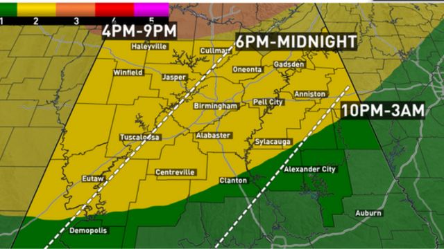
SPC has designated an “enhanced risk” (level 3/5) of severe thunderstorms for the Tennessee Valley of North Alabama, with a “slight risk” (level 2/5) extending as far south as Demopolis, Clanton, and Ranburne. South Alabama faces a “marginal risk” (level 1/5).
The primary window for strong to severe thunderstorms will be from roughly 4:00 p.m. tomorrow to 2:00 a.m. Wednesday. The primary threat to Alabama will be severe, potentially catastrophic straight-line winds. Tornadoes will be most likely to form to the north, while an isolated tornado or two in North Alabama tomorrow night is not impossible. There is also the possibility of some hail.
- Auto Insurance Shopping Rises in Response to Soaring Insurance Rates: Report
- Avoid These 7 Missteps When Refinancing to a Lower Mortgage Rate
- Rising Home Prices Amid Slight Mortgage Rate Dip: Analysis
- Fresno County’s Groundbreaking Initiative: $500 Monthly Payments in New Guaranteed Income Program, Here is Who is Eligible
- Unlocking Financial Freedom: 5 Reasons to Opt for Personal Loans in Credit Card Debt Repayment
Rainfall in Alabama’s northern half will range from 1/2 to 1 inch, while the southern counties will receive less than 1/2 inch.
Wednesday will be breezy and much cooler in North Alabama, with highs ranging from 57 to 64 degrees with persistent clouds. South Alabama will get plenty of sun Wednesday, with a high in the 60s. Thursday and Friday will be sunny and cool statewide, with highs in the 60s.
- Will Everyone Get a $12,000 Stimulus Check in 2024? Find Out Eligibility
- $6400 Stimulus Checks in 2024: What You Need to Know About Eligibility and Payment Dates
- IRS 4th Stimulus Check 2024: Comprehensive Guide to Eligibility and Payment Dates
- 3 Smart Moves to Make Once Your Savings Reach $50,000, Here Are Crucial Actions to Take
- 3 Effective Ways to Pay Off Student Loans on a $50K Salary or Less, Know Here!
FROST/FREEZE THREAT: Frost is expected over the northern two-thirds of Alabama on Friday and maybe Saturday early. Colder areas may see freezing temperatures. Temperature forecasts will be important for growers to watch.
THE WEEKEND: Dry weather continues with plenty of sun and highs in the 70s. The next probability of showers will come around the middle of the next week.