


Severe Storm Alert: Over 50 Million From Texas to Virginia Face Tornado Threat
A large storm system is moving across the country, posing the potential of severe storms, flooding, and snow across sections of the Central and Eastern United States, from Texas to Virginia.
On Monday, the risk of devastating weather increases, with over 50 million people in Texas, Oklahoma, and Missouri potentially facing severe storms.
Here’s how the dangers will unfold over the next few days.
- Auto Insurance Shopping Rises in Response to Soaring Insurance Rates: Report
- Avoid These 7 Missteps When Refinancing to a Lower Mortgage Rate
- Rising Home Prices Amid Slight Mortgage Rate Dip: Analysis
- Fresno County’s Groundbreaking Initiative: $500 Monthly Payments in New Guaranteed Income Program, Here is Who is Eligible
- Unlocking Financial Freedom: 5 Reasons to Opt for Personal Loans in Credit Card Debt Repayment
Monday: An increased possibility of destructive wind gusts and tornadoes.
The major area of interest on Monday is from northeastern Texas to western Indiana, where the Storm Prediction Center (SPC) has issued an elevated risk for severe storms, or a level 3 out of 5.
- Will Everyone Get a $12,000 Stimulus Check in 2024? Find Out Eligibility
- $6400 Stimulus Checks in 2024: What You Need to Know About Eligibility and Payment Dates
- IRS 4th Stimulus Check 2024: Comprehensive Guide to Eligibility and Payment Dates
- 3 Smart Moves to Make Once Your Savings Reach $50,000, Here Are Crucial Actions to Take
- 3 Effective Ways to Pay Off Student Loans on a $50K Salary or Less, Know Here!
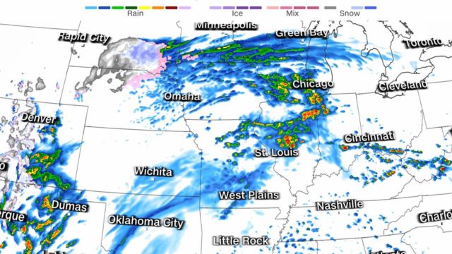
Dallas, Fort Worth, Oklahoma City, Springfield, and St. Louis are among the cities in the elevated risk zone, where the main risks are tornadoes (some of which may be EF2+), big to very-large hail (greater than 2 inches in diameter), and destructive wind gusts.
“The severe threat will peak afternoon/evening in the southern Plains with the greatest threat for the Ohio Valley vicinity being the evening/overnight period,” cautions the National Weather Service.
A small chance of severe storms, or a level 2 of 5, extends from central Texas to western West Virginia, affecting San Antonio, Indianapolis, Austin, Kansas City, and Cincinnati.
A minor danger of severe storms, or level 1 of 5, extends from Texas to eastern Virginia, encompassing Amarillo, Shreveport, Richmond, and Columbus, Ohio. The greatest hazards are huge hail and destructive wind gusts, but the possibility of a tornado cannot be discounted.
According to research, tornadoes at night are more than twice as deadly as tornadoes during the day. Tornadoes are difficult to see in the dark, and the main reason is that people are sleeping.
Flood warnings are in force for more than 8 million people from eastern Indiana to western Maryland, beginning Monday morning and lasting until late Tuesday. Rainfall of 1-4 inches is possible, with isolated totals up to 5 inches.
More snow is expected in parts of the Northern Plains on Monday, while the Upper Midwest may receive a wintry mix.
Tuesday: Severe storm system moves east.
A higher chance of severe storms extends from northern Alabama to southern Ohio, affecting Nashville, Louisville, and Lexington-Fayette, Kentucky.
The greatest concerns include huge hail, damaging wind gusts, and tornadoes, which are similar to the dangers in areas with a low probability of severe storms that stretch from central Mississippi to central Ohio and include Cincinnati, Birmingham, Knoxville, and Chattanooga.
Jackson, Mobile, Memphis, Indianapolis, Pittsburgh, Washington D.C., Baltimore, and Richmond are among the cities under level 1 of 5 threat on Tuesday. Baltimore is still recuperating from the Key Bridge disaster.
Temperatures at the northern edge of the storm are low enough to produce a wintry mix and even some April snowfall. Parts of the Northern Plains and Upper Midwest may receive a wintry mix on Monday, before the threat of winter precipitation shifts to the Great Lakes and interior Northeast as early as Tuesday and lasts through Thursday.
Cities such as Chicago may receive a few flurries, but no significant accumulation of snow is forecast. The largest snowfall totals are forecast in northern Michigan and higher elevations of the interior Northeast, such as the Green, White, and Adirondack Mountains.
The major cities in the Northeast are now expected to get only rain.