


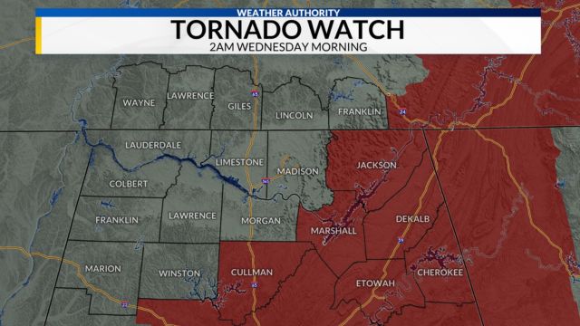
Severe Weather Update: Tornado Watch in Effect for Central Alabama
The National Weather Service said that in Chilton County, a tornado passed through the area near Riderville, Plantersville, and Parnell. The National Weather Service has issued a Tornado Watch 82 for 33 counties in central Alabama until 2 AM CDT Wednesday.
These counties are Autauga, Bibb, Calhoun, Chambers, Cherokee, Chilton, Clay, Cleburne, Coosa, Dallas, Elmore, Etowah, Fayette, Lamar, Lowndes, Marion, Montgomery, Perry, Pickens, Shelby, St. Clair, Talladega, Tallapoosa, Walker, and Winston. Keep an eye on the weather and be ready for it to change. North Alabama’s Cullman, DeKalb, Jackson, and Marshall counties are also on the Tornado Watch.
Parts of North and Central Alabama are getting rain and storms right now, but they’re not too dangerous, and there are no severe weather threats as we head into the late night. The new HRRR model, on the other hand, says that the area is still very unstable, especially along and south of the I-20 corridor.
- Auto Insurance Shopping Rises in Response to Soaring Insurance Rates: Report
- Avoid These 7 Missteps When Refinancing to a Lower Mortgage Rate
- Rising Home Prices Amid Slight Mortgage Rate Dip: Analysis
- Fresno County’s Groundbreaking Initiative: $500 Monthly Payments in New Guaranteed Income Program, Here is Who is Eligible
- Unlocking Financial Freedom: 5 Reasons to Opt for Personal Loans in Credit Card Debt Repayment
This model also shows that there is a good chance of tornadoes in these places. There is also a lot of wind shear and helicity, which can cause severe storms. From the southern part of Shelby County to the state line with Georgia near Heflin, there is a good chance of spinning updrafts, which can turn into tornadoes. The dewpoints, which show how much water is in the air, are still high, which makes things even less stable.
The National Weather Service (NWS) in Birmingham has dropped the Tornado Watch for Greene, Sumter, Tuscaloosa, and Walker counties. Cullman County has also been taken off the watch list by the NWS in Huntsville.
- Will Everyone Get a $12,000 Stimulus Check in 2024? Find Out Eligibility
- $6400 Stimulus Checks in 2024: What You Need to Know About Eligibility and Payment Dates
- IRS 4th Stimulus Check 2024: Comprehensive Guide to Eligibility and Payment Dates
- 3 Smart Moves to Make Once Your Savings Reach $50,000, Here Are Crucial Actions to Take
- 3 Effective Ways to Pay Off Student Loans on a $50K Salary or Less, Know Here!
Remember to keep up with the weather until the danger is gone from your area. Also, Wednesday will bring cooler temperatures and strong winds from the northwest.
REST OF THE WEEK: Tomorrow, with highs in the 60s, it will be windy and much cooler in the state. For the most part, clouds will stay over the northern counties all day. In the south, however, there will be lots of sun. Thursday and Friday will also be dry, and there will be a lot of light each day.
Lows will drop into the 30s across most of the state on Friday and Saturday morning, and there is a good chance that frost will form. Also, colder places might get as cold as freezing. Growers will need to pay close attention to the weather reports. The good news is that this is likely to be the last frost or freeze threat for the season. most of the time.
THE ALABAMA WEEKEND: The weather will stay sunny all weekend. The high on Saturday will be in the 60s and the low to mid-70s on Sunday.
THE WEATHER FOR THE WEEK: It’s going to be a rough week with a chance of rain every day. By the middle of the week, stronger storms are likely.