


Mid-atlantic Braces: Persistent Severe Weather as Storm Nears Journey’s End
Wednesday defines the third day of a severe weather outbreak that has caused devastation from Texas to the Ohio Valley and the Southeast, as well as the death of one person in Kentucky.
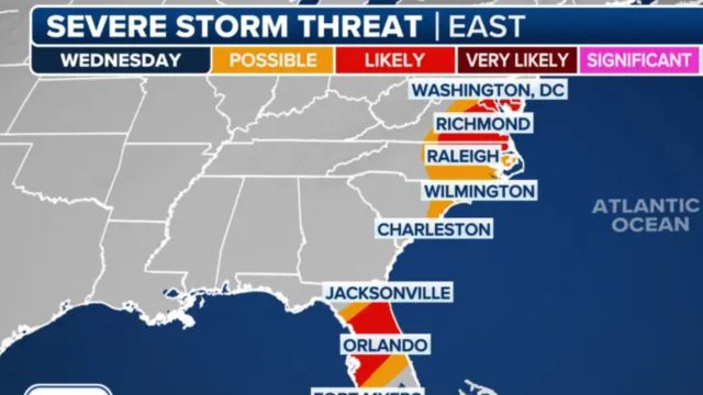
This time, the worst weather hit the East Coast, especially in Virginia and Florida.
Because atmospheric conditions are less conducive to severe weather, the likelihood of damaging winds, huge hail, and tornadoes is lower than on Monday and Tuesday.
- Auto Insurance Shopping Rises in Response to Soaring Insurance Rates: Report
- Avoid These 7 Missteps When Refinancing to a Lower Mortgage Rate
- Rising Home Prices Amid Slight Mortgage Rate Dip: Analysis
- Fresno County’s Groundbreaking Initiative: $500 Monthly Payments in New Guaranteed Income Program, Here is Who is Eligible
- Unlocking Financial Freedom: 5 Reasons to Opt for Personal Loans in Credit Card Debt Repayment
“So, we go from a (Level) 4 out of 5 risk now to a 2 out of 5,” FOX Weather Meteorologist Steve Bender said.
“It does not imply you should let go of the gas pedal. You still consider what those hazards could be.” NOAA’s Storm Prediction Center identified two zones with the highest probability of severe weather on Wednesday: one from Delaware to northern North Carolina, and another spanning North and Central Florida.
- Will Everyone Get a $12,000 Stimulus Check in 2024? Find Out Eligibility
- $6400 Stimulus Checks in 2024: What You Need to Know About Eligibility and Payment Dates
- IRS 4th Stimulus Check 2024: Comprehensive Guide to Eligibility and Payment Dates
- 3 Smart Moves to Make Once Your Savings Reach $50,000, Here Are Crucial Actions to Take
- 3 Effective Ways to Pay Off Student Loans on a $50K Salary or Less, Know Here!
A Tornado Watch has been issued for the mid-Atlantic region, which does not encompass Washington or Baltimore.
Nearly 30 million people in these locations are at risk of destructive wind gusts, huge hail, and even a tornado or two. A cold front is still moving across the East Coast, bringing with it a slew of rain and thunderstorms.
The storm system is moving quickly, with some thunderstorms moving east at speeds exceeding 50 mph. Some of the storms are becoming more severe, triggering warnings throughout many counties.
The majority of the storms are forecast to move off the East Coast by sundown, but the winter weather on the storm system’s northern edge will last at least until Thursday. April is normally the second busiest month for severe weather.
The fourth month of the year is often associated with an increase in severe weather outbreaks when seasonal air masses collide across the eastern half of the nation.
April is usually the second busiest month for tornadoes, followed by May.
El Niño, a global climatic pattern, has been shown to reduce severe weather in the Lower 48. The current year appears to be consistent with previous El Niño episodes.
According to NOAA’s Storm Prediction Center, tornado activity this year has been lower than typical, while hail and destructive wind reports have been closer to average.