


Heatwave Alert: Florida Cities Hit All-Time Highs, Map Reveals
As Florida battles its first heat wave of the year, several cities in the southwest shattered records on Wednesday.
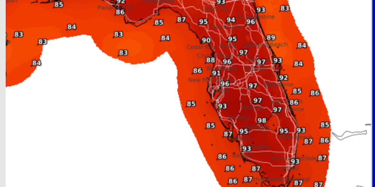
According to the National Weather Service (NWS), Tampa beat its record for the highest daily temperature at 97 degrees.
The previous mark was 96 degrees, established on May 29, 2006. Sarasota-Bradenton, where temperatures reached 96 degrees, and Winter Haven, where they reached 99, also established records.
- Auto Insurance Shopping Rises in Response to Soaring Insurance Rates: Report
- Avoid These 7 Missteps When Refinancing to a Lower Mortgage Rate
- Rising Home Prices Amid Slight Mortgage Rate Dip: Analysis
- Fresno County’s Groundbreaking Initiative: $500 Monthly Payments in New Guaranteed Income Program, Here is Who is Eligible
- Unlocking Financial Freedom: 5 Reasons to Opt for Personal Loans in Credit Card Debt Repayment
Punta Gorda also tied its record for daily high temperature of 98 degrees. The two previous hot periods in the city were 1945 and 2006. The 97-degree daily record was also tied in Brooksville, Florida.
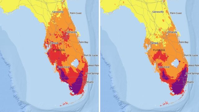
In a post to X, formerly Twitter, on Wednesday afternoon, WINK Chief Meteorologist Matt Devitt called the scenario a “scorcher” and shared a map depicting parts of southwest Florida that reached highs of 100 degrees during the day.
- Will Everyone Get a $12,000 Stimulus Check in 2024? Find Out Eligibility
- $6400 Stimulus Checks in 2024: What You Need to Know About Eligibility and Payment Dates
- IRS 4th Stimulus Check 2024: Comprehensive Guide to Eligibility and Payment Dates
- 3 Smart Moves to Make Once Your Savings Reach $50,000, Here Are Crucial Actions to Take
- 3 Effective Ways to Pay Off Student Loans on a $50K Salary or Less, Know Here!
The cities in Florida join more than a dozen others that endured record-breaking heat over the long weekend. On Sunday, daily highs were attained in Fort Lauderdale (96), West Palm Beach (95), Miami (96), and Orlando (97).
SEE MORE – Severe Weather Alert: Tornado Watch for Hampton Roads and North Carolina
Melbourne, Florida, saw its second-warmest May temperature ever on Memorial Day, reaching 98 degrees. At 98 degrees on Monday, Fort Pierce tied for its warmest day of the month.
For the Gulf of Mexico, southeast, southern, and southwest Florida as well as the Atlantic coastal seas, the NWS issued a hazardous weather forecast on Wednesday afternoon.
Forecasters cautioned that certain counties may have heat indices of 100 to 105 degrees during the day, and that by Wednesday evening, the region would see sporadic showers and thunderstorms.
The NWS stated that there is a chance of scattered storms for the remainder of the workweek, adding that “any storm will be capable of gusty winds, frequent lightning, and heavy downpours.”
“The rip current risk will increase over the east coast Friday into the weekend as onshore flow increases,” forecasts stated.
Over the weekend, southern Texas also experienced temperatures above 100 degrees. Later this summer, a “tremendous dome of heat and drought” that has been rising over Mexico will also affect portions of the southwestern and south-central U.S., according to a news release from Accuweather’s forecasters to Newsweek.
In the upcoming weeks, the system is predicted to start moving north. AccuWeather Lead Long-Range Meteorologist Paul Pastelok stated in the press release that there is “potential for a prong of triple-digit heat to develop over the interior valley of California by the middle of next week.”
“But, most definitely, temperatures will trend upward significantly as a bubble of the Mexico heat moves up and into the western U.S.,” Pastelok said.